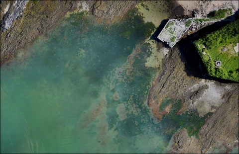
Biologists are mapping Maine's Casco Bay eelgrass beds before a planned fall restoration pilot, building a baseline that can show whether the work pays off. A September 16 U.S. Fish and Wildlife Service report describes drone surveys backed by underwater cameras, rather than treating aerial pictures alone as evidence of meadow health.
In July 2026, the Gulf of Maine Coastal Program surveyed seven beds: three declining, three healthy and one that had disappeared but was beginning to recover. High-resolution imagery helped define meadow boundaries, assess conditions and identify healthy donor beds with reproductive shoots that could support restoration elsewhere.
Water clarity and sunlight can limit what a drone sees. Working with the Maine Department of Environmental Protection's Marine Mapping Program, researchers used boat-towed underwater cameras to confirm eelgrass along survey transects. Partners are also collecting information on water quality, invasive green crabs and turbidity, all relevant to understanding conditions in the beds.
The next step is still a pilot, not a completed recovery. Partners are evaluating ways to collect and store seeds from healthy meadows for restoration, with the Casco Bay trial planned for fall 2026. The drone team plans to return in summer 2027, when eelgrass reaches peak biomass, to compare meadow size against this year's baseline.
Eelgrass supplies habitat for fish and wildlife while helping water quality and shoreline stability. Some parts of Maine have lost more than half their eelgrass in recent decades, according to the report. For coastal fisheries, the useful test is whether restoration can rebuild that habitat and keep it functioning. These surveys establish how the partners will measure change rather than assume success.
Source & further reading
U.S. Fish and Wildlife ServiceRegulations and conditions change. Check current official guidance before you hunt, dive or travel.